Lake Cumberland - Beneath the Surface
Lake Cumberland, Old Burnside, and the drowned memory beneath the summer water.
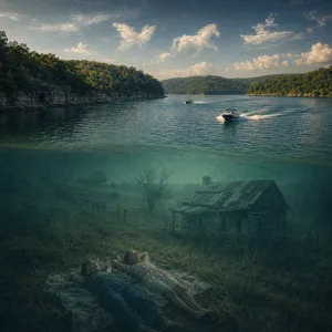
Picture a valley before it became a destination. Not a postcard. Not a marina brochure. Not a drone shot of bright water and pontoon traffic. A real valley. A field sloping down toward the Cumberland. A boy and a girl, maybe ten years old, running through the grass until they drop onto a blanket and stare up at the sky. One points at a cloud and says butterfly. The other says horse. Then the shape shifts and becomes a boat. They laugh, because clouds do that. They change in front of you and call it weather.
Years later, maybe decades later, real boats would pass above that same place at speed. Wake rolling behind them. Engines humming. Coolers packed. Families laughing. Summer in full swing. And beneath them, somewhere under the green water, would be that lost field, that vanished blanket, that skyward childhood moment, and a whole landscape that once thought it was permanent.
That is Lake Cumberland to me. Not just one of Kentucky’s great recreational places, though it is certainly that. Not just coves, cliffs, marinas, fishing, and the ritual movement of summer people from dock to dock. It is also a flooded memory field. A remade geography. A bright, beautiful surface stretched over roads, rail beds, foundations, farms, ferry crossings, stories, and the ordinary lives of people who had to move because a new century required a dam.
The Engineering Version
The official story is clean enough. The U.S. Army Corps of Engineers built Wolf Creek Dam for flood control and hydropower. The project was authorized by the Flood Control Act of 1938 and the Rivers and Harbor Act of 1946. Construction began in August 1941, was delayed by World War II, and the dam was completed for flood-control operation in 1950; three generating units went online in 1951 and the remaining three in 1952.1 The result was Lake Cumberland, a reservoir 101 miles long with 1,255 miles of shoreline, backed by a structure 5,736 feet long and 258 feet high.2
That is the engineering version, and it is true. But engineering truth and human truth are not always the same scale.
Old Burnside
Human truth is Old Burnside. Human truth is what was there before the water. Old Burnside was once a real riverside town with railroads, steamboat docks, homes, businesses, and all the layered daily life that turns a place into something more than coordinates. When the dam changed the river, Old Burnside did not simply decline. It was deliberately surrendered to the lake. By the time Lake Cumberland reached full pool in 1954, nearly all of Old Burnside was underwater, making it the only Kentucky town intentionally flooded to create a reservoir. Many residents relocated uphill to what became New Burnside.3
That phrase, New Burnside, carries more weight than it first appears to. New Burnside sounds practical, civic, forward-looking. It also quietly admits that the old one still matters. It acknowledges a replacement while preserving a ghost. The name itself is a bridge between what remained above the waterline and what did not.
And the old one is still there, in a way. On especially low-water years, remnants of Old Burnside can still be seen: stone foundations, concrete sidewalks, sections of railroad line, the residue of an ordinary town now living in a different element.4 That detail is what turns the lake from scenery into something more liminal. It is not just that the past existed here. It is that the past occasionally returns to the surface, just enough to remind everyone that the water is keeping records.
Around the lake, the modern names feel almost casual now. Burnside. Waitsboro. Fishing Creek. General Burnside Island. Jamestown. Conley Bottom. Wolf Creek. Harmon Creek. Beaver Creek. Lee’s Ford. Pumpkin Creek. They sound like places for campgrounds, docks, and directions you give to somebody hauling a boat. And they are. But they are also part of an older map, one that was not drawn for recreation first. Before the houseboats and rental slips and summer traffic, these were lived spaces. Working spaces. Family spaces. Places where roads mattered because they led to somebody’s porch, church, store, or field, not just a boat ramp.
That is what reservoirs do when they are large enough. They do not merely hold water. They edit a region.
To say that Wolf Creek Dam brought major benefits is not wrong. It reduced flood risk, generated electricity, improved downstream navigation, and helped create one of the signature landscapes of southern Kentucky.5 It also laid the groundwork for a recreation economy that now defines much of the lake’s identity. People fish here, vacation here, retire here, launch from here, drift here, fall in love here, and build memories here that are fully real in their own right.
Stories Under the Waterline
But every paradise with a waterline has a story underneath it.
The old stories around Burnside are especially good because they carry both movement and loss. There were steamboats here once. The Rowena, launched around 1912, became one of the iconic vessels on the Cumberland and symbolized Burnside’s river commerce before it sank in 1934.6 There were rail lines. There were hotels and small industries. There was a town close enough to the river to live by it and vulnerable enough to be remade by it. That is old Kentucky in one frame: transportation, trade, stubbornness, beauty, and the occasional hard lesson that the landscape you depend on can be reorganized by someone with survey tools, federal authority, and a concrete plan.
Memory After Submersion
What fascinates me is not just the displacement itself, but the way memory behaves after a place is submerged. A town on dry land leaves obvious scars when it dies: boarded windows, vacant lots, an old sign hanging on a building no one has touched in fifteen years. A town under a lake disappears more completely, but also more strangely. It becomes rumor, family story, diver lore, local history, low-water photographs, and the sentence old-timers say with a certain tone: “There used to be something down there.”
That is Into Entropy territory all day long.
Because Lake Cumberland is not merely about erasure. It is about transformation so total that the replacement becomes normal. Whole generations now know the lake first as a place of pleasure and movement. They know cliff lines, marina fuel docks, quiet coves after Labor Day, the long pull of summer weekends, the beauty of morning fog near the water, and the particular civilization of coolers, sunscreen, anchors, wet towels, and boat keys. All of that is real. All of that matters. It does not cancel the old world beneath it. It simply lives above it.
That is the emotional complexity of the lake. It is not a grave in the simple sense, and it is not just progress either. It is a layered place. One world flooded. Another world launched.
Maybe that is why lakes like this produce a different kind of nostalgia than old towns on land. On land, you can walk the street and say, “This used to be the drugstore,” or “That was the old theater,” or “My grandparents lived over there.” On a lake, you are often guessing across water. The reference points are hidden. The memory has to work harder. The imagination fills in what the eye cannot confirm.
Fields of Memory
Somewhere beneath the surface near old shorelines, there are places where children once ran through fields, where people loaded wagons, where someone called a dog in at dusk, where porch conversations ended with “see you tomorrow,” assuming tomorrow would arrive in the same landscape. Somewhere, there were roads that led somewhere concrete, not just toward the edge of a dock. Somewhere, there were homes whose front rooms heard thunderstorms long before they ever heard the churn of wakeboats.
Now the water carries different sounds. Propellers. Laughter. Music skipping across coves. The clean impatience of modern leisure. It is easy, if you love the lake, to feel almost guilty saying any of this, as if acknowledging what was lost somehow insults what exists now.
It does not.
The beauty of Lake Cumberland is real. The losses that made it possible are also real. Both truths can coexist, even if they make the water feel deeper.
And maybe that is the best way to understand a place like this. Not as a simple before-and-after, not as a morality tale, not as a complaint, not as sentimentality for its own sake, but as a reminder that landscapes have biographies. Some are written in roads and storefronts. Some are written in flood pools and reservoir maps. Some are written in absence.
Lake Cumberland is one of Kentucky’s great acts of environmental revision. It covered an older world and made a newer one possible. It displaced people, reshaped communities, flooded memory into the terrain, and then gave the region back a different identity built around water, recreation, and a changed horizon.
That is why I keep returning to the image of those two children in the valley. They do not know yet that they are lying in a future lakebed. They do not know that the cloud-boat above them is foreshadowing. They are just children on a blanket in a field, looking up. That innocence matters because every large public project, every dam, every bypass, every redevelopment plan, every “improvement” eventually passes through somebody’s ordinary day like that. Before a place becomes historic, strategic, or economically useful, it is usually just home.
And if you spend enough time around Lake Cumberland, I think you can feel that old word still moving under the newer one.
Not literally, perhaps. Not in the spooky-tourism sense. But in the quieter way a place carries what it replaced. In the low-water remnants of Old Burnside. In the stories passed down. In the names still attached to creeks and bends and marinas. In the fact that beneath the motorboats, beneath the summer sky, beneath the clean recreational image, there are still fields of memory down there.
A lake can hold floodwater.
It can also hold a past.


Discussion